About Me


Masood Bari is a Gis Analyst having six years of experience in GIS.His expertiese in Excel,SQL,Webgis,Leaflet,Database,Pythonscripting,Data science,Image analysis
I Completed projects For Clients Such as RTA,Alain Muncipality,Dhafrah Muncipality,Karachi-Electric.
ASSESSMENT OF ROAD CONDITION AND DATA COLLECTION OF AL-DHAFRA CITY,Al Ain City,RTA.
Software: ArcGis, Arcgis Server,Survey 123, Arcgis Pro,Oracle,Notepad++,Sql Server,Adobe,PostgreSql,Erdas Imagine,Ms office,HTML,Geoclean,OrbitGis, Operation Dashboards for Arcgis,Trimbler(Assets Modelurer System),Qgis,Blender ,Jupyter Notebook,Autocad,Revit,Sketchup,Opencv,Machine learning,Optimization,Illustrator,Premiere pro,After Effects,Photoshop
Certifications: Zero Semester Certificate in Rs and GIS (Institute of Space and Technology) Data Science Certification From Frontier Institute Of Technology
Publications:Conference Participant and Presented Poster in ICASE2015 Conference Participant And Presented Poster in ICASE 2021 about the shortest route with network analyst in Karachi area
POSTGRADUATE RESEARCH WORK:Drought Monitoring Using Modified Soil Adjusted Vegetation Index in Sind. Finding the closest route and service area with the help of network analysis & web application with the help of Arcgisapi for Java script. Automatic Traffic Sign type detection with the help of Machine Learning.
CV:
PROFESSIONAL EXPERIENCE
Engineering Consultant International Private Limited, Dubai, UAE Jan 2019/Present Senior GIS Analyst, GIS Department
Project: ASSESSMENT OF ROAD CONDITION AND DATA COLLECTION OF AL-DHAFRA CITY
This Project is related to Road Condition Assessments and Data Collection in Al Dhafra City MainRoads and Sector roads. The objective is to develop the Dhafra City Road inventories Structure And Asset Pavement Condition of roads. My responsibility on this project is comprised of the following tasks:
• Creating and editing routes. Making Pavement Condition Index Distress at the 100-meter section.
• Working On Linear Referencing to make a Linear Reference Chainage on 1-meter points and give these chainages to other features by using spatial join.
• Capturing features using Trimble software like road features road marking line, curbstone approximate 34 features into total identifying their condition and measurement capture their 360-degree images and linked into GIS Geodatabase with their image and attributes data and make final data of road inventory features of Dhafrah city.
• Routing cabling of street light linked with control cabinet of Dhafrah city in GIS according to client requirement and filling their attributes like which cable is connected with which control cabinet and make a whole spatial data in GIS with the shape of geometry line, point, and polygon.
• According to Client Requirement Correcting Geometry of Right of way Features by using Data Reviewer and Topological tools.
• Managing and administering Postgres SQL server database and web services feature service with ArcGIS server and ArcGIS pro.
• Supporting Engineering department by giving maintenance strategy in gis BOQ(billing of quantity) asset value and their maintenance cost.
• Managing Staff of GIS by assigning work to them and helping in their work by making python scripts and tools with a Model builder.
• Extract Feature or object by using Image Analyst Deep learning tool from ArcGisPro and helping in quality insurance of data by comparing with them our right of way feature data.
• Making schema and appending features into it according to client requirements.
• GIS integration of Falling weight Deflectometer points and joining attributes with the help of join tool with excel raw data and filling attributes like their modulus values and assigning them their unique id in every point of FWD.
• Using Autocad and sketchup making 3d drawings and layouts of buildings and road features and make drawings in 2d of road features and buildings.
• Data Attributes check and Geometry Checks By Data Reviewer And Topology Tool.
• By using a Model builder to check the hyperlink of images and videos which is linked with our GIS spatial data in all layers.
• Making reports in ms word for clients and by using different formulas in excel analysis and making dashboards for clients.
• To get the data from Autocad drawings or as-built drawings and integrate into GIS.
• Extract the data attribute from Autocad drawings and integrate it in GIS.
• By Using QGIS Geoserver publishing layers and making an application from it for clients.
• Making layouts for sector and area-wise by using different cartography techniques.
• GIS integration of Global Penetrating Radar layers at 500-meter sections according to client requirement and adding Linear Referencing System chainage on it by using spatial join and splitting points with 1-m chainages.
• Using leaflet and geojson making web application of GIS.
• Using Jupyter notebook detect the traffic sign type with the help of machine learning(AI).
• Using GITHUB publishing our webapplication and feature service of GIS on domain.
• Using spatial join and python scripting and SQL queries.
• Making Scripts in ArcGIS Python(arcpy) to automate the task.
• By using VBA scripts on excel to automate the task for GIS purpose.
• Maps layout with the help of Adobe illustrator and ArcGIS to visualize more precisely.
• Model Builder in Arcmap to append the shapefile feature into schema gdb of lines, point, polygon features.
• Using model builder to automate the task for different scenarios.
• Publishing layer through ArcGIS server and ArcGISpro to use the services of layers.
• Creating and Adding lidar data runs into Trimble Software.
• Geo reference, image mosaic, classification , indices and use all geo processing tools in ArcGIS pro and Erdas Imagine.


Understand the idea Do Analysis on the base of spatial analysis mapping.
Web spatial mapping gis application with the help of leaflet html and css.
Accuracy and best visulaization Data.
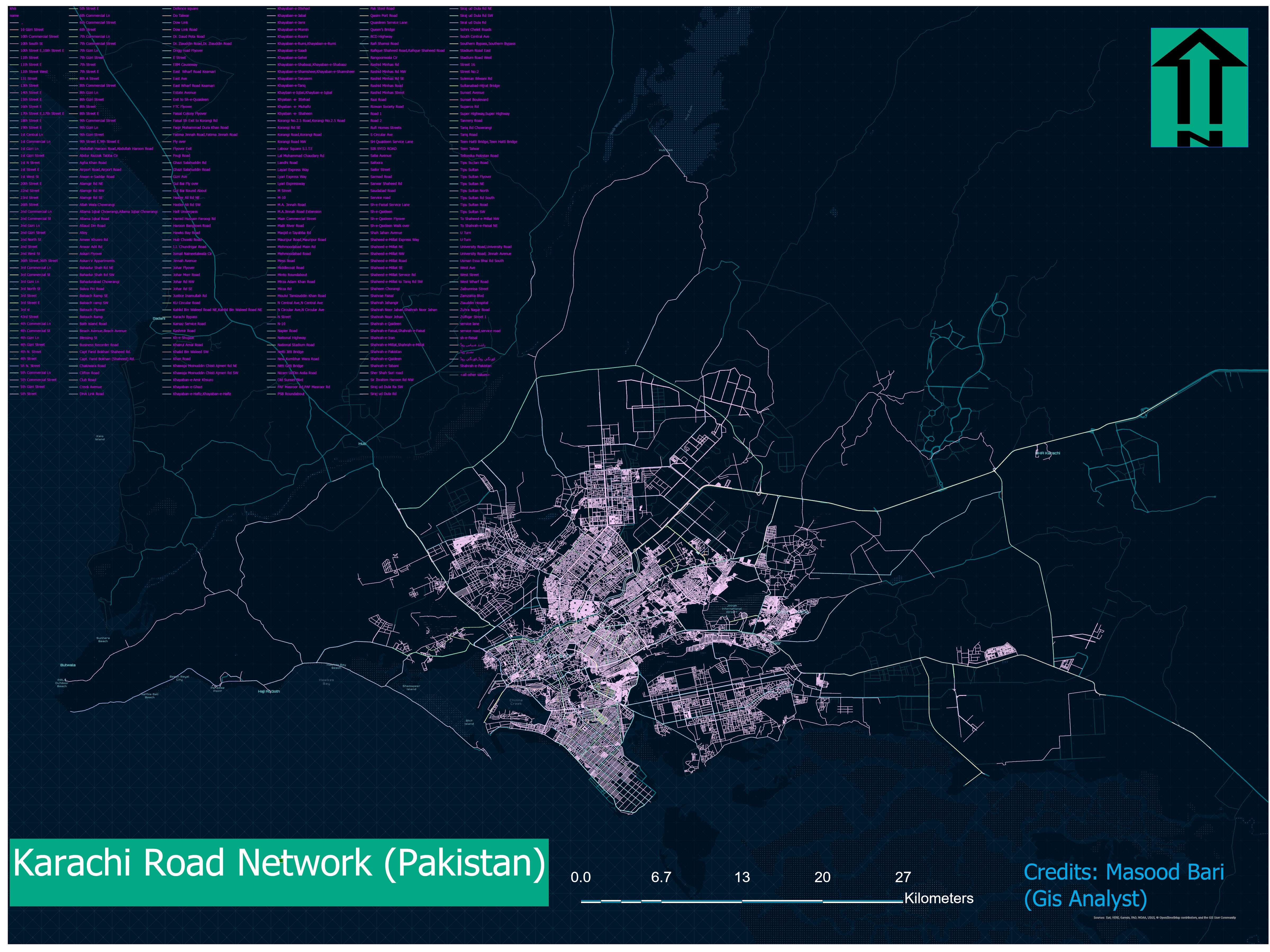
Pakistan

Road Network
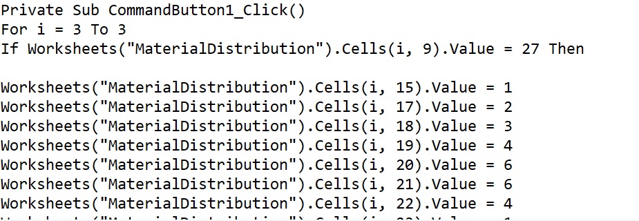
VBA,Python Scripting